About Me

The Returd Highway - from Retirement to Oblivion (possibly via incontinence and dribbling or both). We walked 1000 km of it last year on the Bibbulmun Track, but to discover more of the true Oz, we needed wheels (four) and a bed. We just got them. We plan to just take off and make for significant points - how we get there is a matter for chance and circumstance. So hold on to your hats and anything else that might blow off, we'll keep you posted on our voyage of discovery.

Monday, 20 May 2019

Carnegie, Lorna Glen, Narndee and Home


Carnegie, Lorna Glen, Narndee and Home

Very few other travellers stayed at the Carnegie station camping area while we were there but two vehicles drove in one late afternoon – Lyle and Owen, two guys from the Department of Parks and Wildlife, accompanied by a guy named Neil Hamilton whom we were informed is the guru of Western Australian birds. They were doing a patrol up into the Gibson Desert looking for sandalwood poachers but were also hopeful to make a sighting of the famed night parrot, widely held to be extinct but like John Farnham, refusing to lie down. We hit it off around the campfire that night – we knew quite a few mutual acquaintances from when I used to work around fire and emergency people, and Maurs wanted to pick Neil’s brain about the local birdlife. They suggested that we visit another station on our way back called Lorna Glen. It was only about 40 kilometres off the main road and yep, you guessed it, the road is fine, and yep, you guessed it, we found ourselves back on a stretch of badly rutted road and us filling in large holes with rocks in order to negotiate a passage to Lorna Glen. 
Lunch down by the billabong

That way to Lorna Glen

More ruts Fawltey!

I guess we were old hands by now and we rolled into this really well maintained station area to be met by the caretakers, a Sydney couple who make the massive trip with their caravan every year to look after this remote and isolated station in the middle of nowhere for five months (it is a migration pattern that would puzzle David Attenborough - as it should because these people weren’t quite sure why they do it themselves). They told us that the station had just been acquired by Native Title and it wasn’t clear what the new land owners (or perhaps, original land owners) intended to do. The Parks and Wildlife Department have built a large enclosure on the station (I’m talking kilometres of perimeter fencing, all electrified) and cleared it of feral predators in an attempt to establish a healthy Bilby community. Our bird guru friend Neal has a theory that Bilbys and the Night Parrot share the same environment so he was hoping that the parrot would also get a leg up within the sanctuary. It seems the Night Parrot prefers to nest on the ground rather than in a tree like most other birds (don’t judge!) and so is vulnerable to anything and everything with a penchant for poultry (you can see that extinction is a risk when a species favours this lifestyle).
Night Parrots (illustration only)
Bilby - cute huh?


Anyway, David the caretaker said that he was going around the fence line that day to check for any breaks. Apparently the electric fence deters cattle who bump into it and get the message that they aren’t welcome but a camel will walk into the fence, get the shock, think “this is unpleasant, I’d better keep going forward!” and bust right through it. We do grow some very big, strong camels out there.

The camp area at Lorna Glen was good – a bit of firewood around and a water supply – what else would anyone need? There was also a shower and a flushing toilet about 100 metres away and this was appreciated too. After 22 days since leaving Kalgoorlie, Kevin and Shirley had finally exhausted their booze supply and we were nursing a little overproof Rum and some Scotch, so the campfire conviviality was reduced to cups of tea and a final nightcap to warm us against the cold desert night. The caretakers had told us of a few things to see and we set off to a place called Turtle Rock Pool. The station tracks were all well maintained and the directions precise. We didn’t see any turtles (or tortoises for that matter) and we didn’t notice a rock that looked like a turtle, but it was definitely a pool of water and a day out.

Turtle Rock Pool in all its glory

Picnic at Turtle Rock
 
We departed Lorna Glen. The road going out the front way was actually very good – 40 kilometres to the Granite Peak Road and another 70 to link up to the Gunbarrel Highway and another 35 to Wiluna. We stopped to pick up a swag that had obviously fallen off a vehicle, figuring that we would hand it in to the local police in Wiluna. No such thing. The local copper didn’t want to know about lost property so we left it at the general store in the hands of the young Japanese back-packer at the checkout. I figured that the chances of the owner actually getting the swag back were miniscule, and naturally I was quite wrong. We got word later (Kev had left his contact number with the store) that a grateful guy asked whether anyone had handed in a swag and was rewarded with a reunion with his beloved bedding.
Wiluna, besides having one of the finest graders in the world such that the main tracks are very driveable, doesn’t have much else. The pub has closed so there’s no beer (much to Kev’s dismay), but the local café was good and the people really friendly.  While we were having lunch a group of local indigenous folk came in, mostly kids, and they went through the place like a tornado – all laughing and running and yelling – it was good to see kids having fun. However we were on a quest. Meekatharra was 184 kilometres away and it was the closest place with beer.
The Wiluna Pub. No beer. No admission!
The road was good – a few strips of bitumen the rest good gravel. We checked in to the caravan park for $25 a night, had a shower and headed straight to the Commercial Hotel. Yes! Cold beer followed by some welcome pub food. We met a few fellow travellers in the pub who had hauled their caravans up the bitumen (a lot of them from South Australia) and we got talking to a couple about their trip which they said they repeated every year from Adelaide to Broome. The lady mentioned how she always prepared a heap of frozen meals so they didn’t have to spend money on the way up and I thought well that really helps the viability of our outback communities.
We were all pretty tired after a relatively long day and we hit the hay around 8.15 pm. Did I mention that there was a 24 hour truck fuelling station just over the road? Truck traffic plies the Great Northern Highway relentlessly, servicing the industry and mining sectors further north in the Pilbara. Trucks stopped to fill up so frequently that we didn’t even notice it after a while and even slept in until 7 am, however if you are a light sleeper and are considering a stopover at Meeka I’d weigh up other options one of which we found to be a place called Peace Gorge located about 3 kilometres out of town, as quiet as can be and quite pretty to boot. You would need to be self-sufficient to stay there though – no water or any facility, but we have certainly noted the area for future trips.
Peace Gorge near Meekatharra
Breakfast the next morning turned out to be a surprise birthday party thrown by Kevin and Shirley for Maurs as this was our last day together before we split, we going south and they going northwest. Kev and Shirley were the best of travelling companions in these remote areas and we have several more camping trips planned with them in the years ahead. All good things end and we said our goodbyes and set sail for Mount Magnet, about 195 kilometres south. The trip south was positively dull. We were now cruising down the Great Northern Highway and the only thing worth reporting was us having to pull off the highway for a few minutes to allow a massive over width truck carrying another massive overly wide vehicle to proceed north. We were very familiar with Mount Magnet having stayed there the year before and we booked in for two nights at the caravan park to reprovision, plan our track home and investigate staying at a station for a few days for a little R&R after our arduous, um ….. holiday.
Maureen's surprise party
Narndee station is just north of Paynes Find and about 40 kilometres off the highway on a well maintained gravel road. They have a large area set aside for campers, and being the only campers, we had our choice of campsite. That situation remained for the rest of the week and apart from a daily visit from Rob the station owner, we were alone. Facilities were minimal but adequate. There was a small shower block powered by a wood fired donkey heater that afforded plenty of hot water so long as you collected the wood and lit the fire, a flushing toilet, and a fireplace made out of an old gas cylinder. This provided both warmth on some really chilly nights and a great cooking area for our camp oven and kettles.
Narndee campsite
Cookin' in the pig
Narndee sunset

I don’t know if you would include these items in the facilities but we had a live-in dog (Bella) and cat (Rebel) who seemed to like our company. There was a sprinkling of different animals around the homestead, and these would wander through from time to time; a couple of retired racehorses, a Shetland pony who thought that he was the boss, two pigs , a calf, and a crazy goat who was convinced that he was the boss.
I'm the boss!
No, I'm the boss!
We're thoroughbreds, we don't listen
 
We spent the time here relaxing and honing up our camp oven skills with Maurs cooking a variety of casseroles using our dehydrated vegetable stock and some (much prized) mutton and lamb shanks that we got from the Mount Magnet Butcher Shop. We discovered that the local area has some quirky history. We went out to an abandoned station (Boodanoo) to see where in the 1920s the owner was shot through the head while standing in the open talking to his wife. The bullet came from a high-powered .303 rifle used by a roo shooter to kill a kangaroo but after despatching the roo the bullet had ricocheted off a rock and struck the hapless station owner. The extraordinary part of all this was that the shooter was two miles away at the time and had no idea that the stray bullet had gone so awry until sometime later. Neither man was known for his good fortune.
Boodanoo Station remains
The other odd piece of history has been termed The Murders in the Murchison and involves a reasonably well known author, Arthur Upfield (creator of the Australian detective character Boney). This all happened in 1929. Upfield was searching for a method to infallibly dispose of a body for a book he was writing and a friend opined a foolproof solution. Another man, Snowy Rowles, a pleasant, handsome young fellow was a party to the conversation. The idea was to incinerate the corpse along with a large animal (likely a kangaroo in those parts) in a very hot fire, crush the bones, and remove any foreign materials from the ashes, such that no one could detect a human presence. A short time later Snowy left with two other men to find work around the area and later returned alone, driving the other man’s vehicle which he claimed to have bought off him. He mentioned that the other two had continued on looking for work (I think you know where this might be going). Another gent went off with Snowy and again Snowy returned alone. Even in remote areas like this people start to be missed and a search for these gents began after a while. Eventually the police came across a suspicious and recent fireplace. Sifting through the ashes they found a wedding ring – that was eventually uniquely identifiable as belonging to the last victim of Snowy’s excesses. I gather that Snowy either forgot the recipe or got lazy and neglected to sift out the foreign material. Upfield shared his misgivings with the authorities, a little taken aback that life was copying art. Further bad luck befell Snowy when a detective sent to make the arrest recognised him as an escaped prisoner from the Geraldton area a few years before. It didn’t turn out so well for Snowy (oh, and that wasn’t his real name either) and he met his fate at the gallows in Fremantle in 1932. Other than that, it keeps pretty quiet around the Murchison.
Rock Pool, Narndee
So after lazy days of moping around the camp soaking up the sunlight, cooking meals in the camp oven and generally keeping the home fires burning it was time to hitch up and leg it back to Perth ahead of a fresh brace of rain coming in from the Indian Ocean. It was a big trip (over 3,000 kilometres all up) and I reflected that I, a city slicker in a small 4WD hauling a camper had driven two famous and demanding roads. It wouldn’t have happened without Maureen’s keenness to do it or Kev and Shirley’s company, and looking back at it, it was a great trip through exciting and unique country. But I think next time I’d do it in a slightly bigger vehicle. Well gotta go. Alaska is calling and I still need to write up our hiking/driving holiday in the UK last year (let alone our journey through India). Ciao to all who have read along with us. I hope you have enjoyed the blog.
Where we went
It's goodbye from us....
and it's goodbye from her...until next time
 

Monday, 1 April 2019

Warburton to Carnegie via the Gunbarrel Highway


Warburton to Carnegie via the Gunbarrel Highway

I had said coming off the Connie Sue that if the Gunbarrel Highway was that bad this here city slicker was not going to Carnegie Station. We were told at the Shire Office that all the roads were “pretty good” around Warburton, and they certainly were - for about two hours. We had spent nearly two days in Warburton – time to move on. We headed out to the west on the Great Central Road (wide, well graded), my options still open, even hit a stretch of bitumen; veered off to the right on the Heather Highway (wide, well graded – I was feeling pretty good here), until we drove past the turn-off to the Tjirrkarli aboriginal community. Within a kilometre we were back where we started (goat track) and by the time we realised that it weren’t going to get any better, it was too late to turn around, and besides conditions may improve once we got off the Heather Highway (you just never know – but I think, dear reader, that you know exactly where this is going!).

After a good day's harvest


Len Beadell's Gunbarrel Plate
Turning left onto the Gunbarrel Highway (the first road that Led Beadell had built in the area) we jinked our way along another 20 kilometres before finding a good campsite and calling it quits for the day. It wasn’t getting any better and there wasn’t any turning around. I didn’t know what we would be calling on the X-Trail to do in order to make the remaining 270 kilometres to Carnegie but I kept Andy’s number close to my heart (if there was a tattooist in Warburton I would have had his number tattooed on my wrist). We built a nice fire and listened to the dingo chorus (with a few wild dogs on bass and percussion) and watched the Milky Way unfold after the setting sun in a way that you will never see in the city. Out here you can make out The Emu, which is an area of relatively few stars embedded in the galaxy starting near the Southern Cross and resembling that bird. No need to join the dots like the ancient Greeks did – you visualise the shape. And it was cold.

Another night, another campfire

The fresh bread just kept coming
Noise travels over distance out there and we heard engines revving the next morning. Six dirt bikes and a supply vehicle were doing a charity ride from Airlie Beach (east coast) to Fremantle (west coast), right through the middle of Australia. Actually there were originally seven bikes but one rider was tucked up in the supply vehicle nursing a broken rib – another 
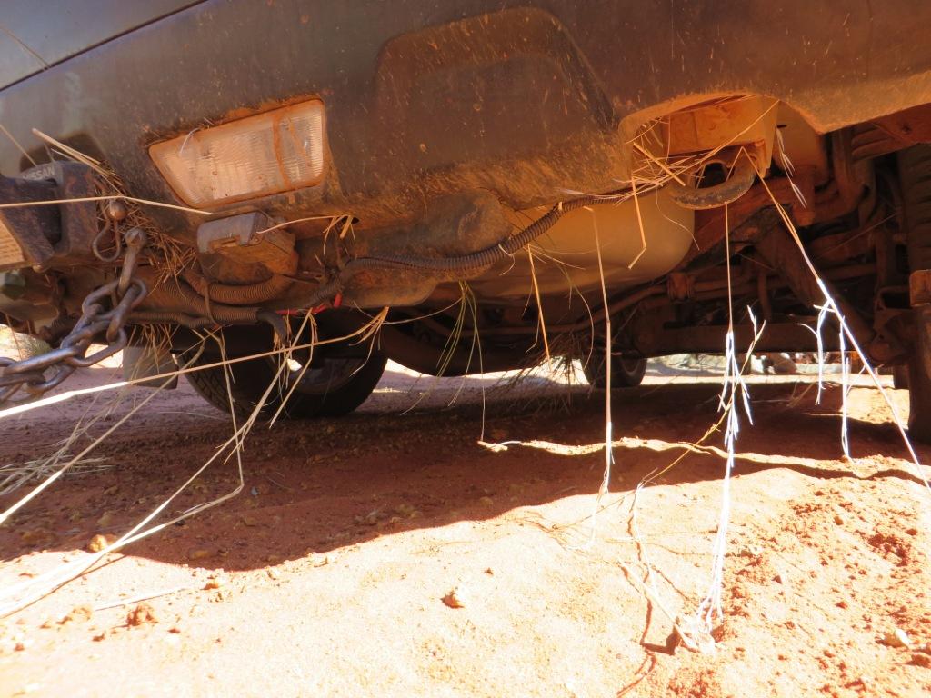
victory to the Gunbarrel. We ventured on even worse roads with some truly serious washaways and even taller grass to harvest underneath the car and to make things just that little more miserable, Maureen misplaced her camera at one of our stops. By the time we discovered it missing there was no point in turning around to look for it and I was resigned to losing all those images of our trip forever.

On the Highway
As we hobbled our way along the road not knowing what chasm or obstacle the Gunbarrel had in store for us next, camera gone, and thinking about all the great holidays we had had before this, I was feeling pretty forlorn and ventured to say that this may turn out to be the worst holiday we have ever had. Maureen would have none of it and frankly told me to stop being so negative and over-thinking things, pull my socks up and don’t be such a pain in the backside. I took these suggestions on board – the Gunbarrel didn’t listen at all and ease up on us, but then again it ain’t married to the Maursinator. We made camp that afternoon and as we were setting up we heard a vehicle coming our way from the east. Maurs was filling her water bottle at the time and headed for the road to meet the vehicle (we were camped far enough off the road that we couldn’t be easily seen). So this couple (who coincidentally we had met at Warburton some days before – small world) were confronted with the sight of this woman walking out of the bush with only a water bottle as if she had been marooned by her irate husband (well there’s a thought). More surprisingly Maureen asked what I thought was a stupid question, “Have you seen a camera?” “What colour was it?” asked the woman. “Blue” said Maurs. “Here it is” said the woman. Unbelievable. That was the moment that I resolved to place my fate in the Universe because magic does happen and maybe, just maybe we had a chance of making Carnegie against all the odds.
Mount Beadell
We proclaimed the next day a rest day. That’s just a rest from driving. We spent the day checking the vehicles (the epoxy seal for my rear diff was holding up under all the bashing that the underbody was receiving), making bread (this was Maurs doing it the hard way, on a campfire), collecting firewood to feed our campfire, and I even previewed to the group a song that fell out of me called (strangely enough) the “Connie Sue Highway Blues” (more shaken out than anything else). Not surprisingly it started out, “Connie Sue, what’d you do to me…” and it went downhill from there but tells the story of how the Connie Sue kicked my butt all the way along it.
The sad tale of the Connie Sue Highway Blues
Heading out the next morning we drove about 150 metres down the track and had to stop to check out the wreck of a Cub Camper similar to ours that obviously didn’t make it to Carnegie Station – just one more vehicle in the series of wrecks strewn along these roads (obviously by people too cheap to give Andy a ring after the event).
Dead camper
The road remained diabolical but we made it to the junction of the Gary Highway where we signed a book and took a photo. Shortly past there is the picturesque Mt Everard, probably the most photogenic feature of the Gunbarrel stretch if not the only feature, and onward for a lunch stop at the Geraldton Bore. We pumped some water out, consigning it to our “washing water” jerry cans, until we had a taste of it – it was really good quality water. It is surprising how good the underground water is out here – desert on top and all that goodness untapped below. With water comes life and there were masses of Zebra Finches in the trees and a lazy and unusual snake worm slithering across the track.
Signing the book at the Gary Highway

A little cloud candy

Is there no end to this road?!!

Sweet water pumped up from below

Is it a snake? Is it a worm? It's a snake worm!

Zebra finches at Geraldton Bore
 
The road is choked with spinifex grass with long stretches of soft sand interspersed with outcrops of sharp rocks. We’re bumping along in the mid–afternoon and noticed a road sign coming up – Welcome to the Shire of Wiluna – we didn’t pay it much attention until we noticed something fairly alien – the bouncing around had stopped! The Shire owned a grader and knew how to use it! Oh joy! We eased our way up to 30 to 50 km/h! We knew the Mungili Claypan was coming up and we searched around there for a possible campsite. It was very exposed country and there had been recent rain so the chances of slipping down into boggy clay were pretty high.
This Shire owns a Grader!!!
We continued on to the junction of the Eagle Highway and decided to set up camp there. It wasn’t ideal but it was after three in the afternoon, it was clouding up and what’s more we had actually travelled 120 kilometres in a single day!
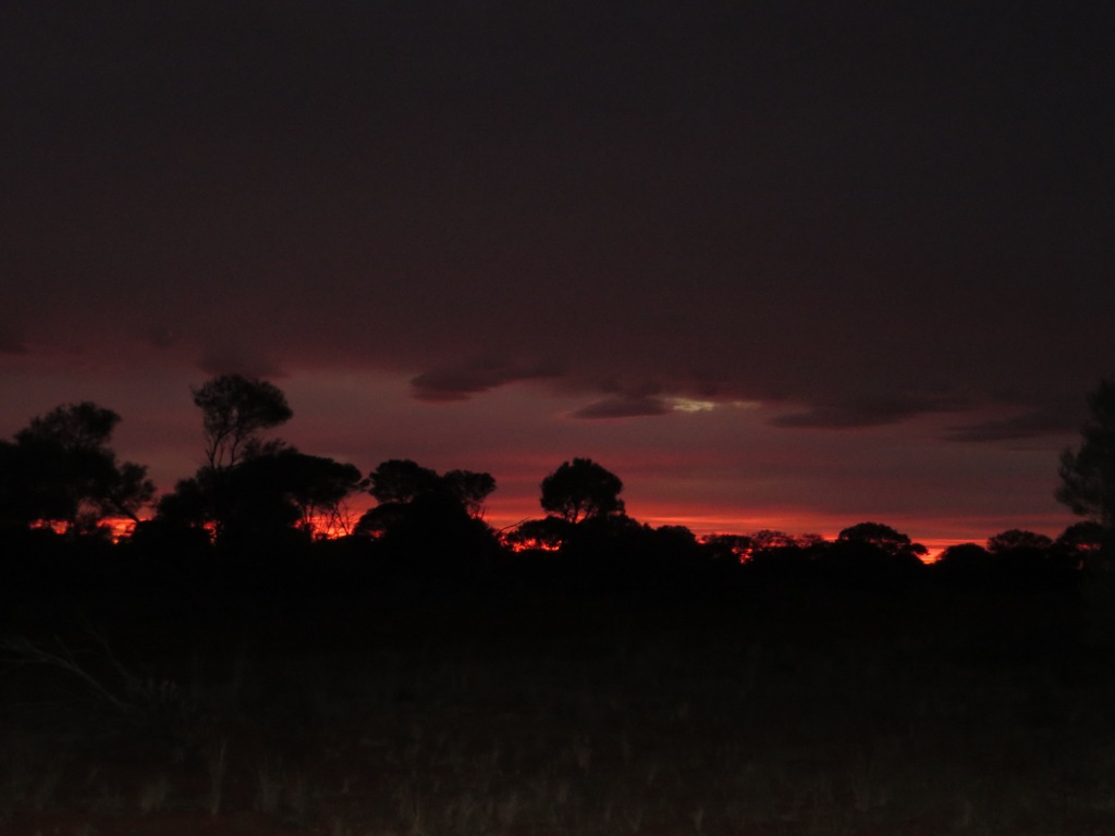
Another great sunset
It rained a little overnight but the clearing cloud deck in the morning made for a spectacular sunrise. As we were enjoying that, as if on cue a herd of about 30 camels streamed past. I expected David Attenborough to come out of the bush to describe it all to us in hushed tones. We departed around 9 am on an excellent dirt road with only a few slow-down points. We were averaging 70 km/h for most of the way in to Carnegie Station where we duly arrived at around 11.30 am. Blessed relief! We cruised in with quite a high sense of achievement and were impressed with the greenery around the property buildings and the grove of citrus trees laden with oranges and mandarins (with the usual “keep away or die” signs to deter tourists from helping themselves without permission). The homestead area looked very basic and the campground was basic but it was a welcome relief to our last five days on the Gunbarrel.

The camels are all pretty healthy
 
Yes but is it art?
 
Kev and Shirley triumphant over the Gunbarrel
 
NOW they put up a warning sign!!

Now if you were to Google Carnegie Station as we did in our planning stage to check on its status and facilities (you know, is there a café, do they take mastercard, is there a bar – none of which there was of course, this is just city-slicker thinking) you would have been bitterly disappointed (as we were) to find the primary heading “Carnegie Station Closed”. Should you read further it turns out that this referred to the Carnegie Railway Station in leafy suburban Melbourne that was getting a facelift at the time of our interest whereas neither drought nor flood nor act of insurrection let alone a little urban train touch-up would ever close down this tough little piece of Central Australia.
Mind you it’s hard to find a “local” out there. Staffing the station was a skeleton crew from the UK, Victoria and Germany who were preparing all the equipment for the forthcoming cattle muster. Having a backyard thousands of square kilometres in extent, the mustering is done by helicopter with a few people (again it’s mostly Europeans, Kiwis and other out of towners) on the ground to open and shut the gates and truck the cattle off to market. And what are all the bronzed Aussies doing, you may ask? I don’t know but my guess is that they’re in Banff running the ski lifts!
You don’t think of this at the time but I’m sure we must have provided a lively topic of conversation around a few campfires as our fellow outback travellers recalled the sight of a Nissan X-Trail pulling a small camper along these stretches of track. “Who in the hell would do that?” There would have been laughter and disbelief and shaking of heads but we did do it and in retrospect I have the utmost respect for that vehicle, particularly after passing the string of burnt-out car bodies standing as monuments for those who did not quite “do that”.
But this was a time to bask in the winter desert sun, cook meals in the camp kitchen, visit the sights (such as the original Carnegie homestead), recharge our own batteries as opposed to the solar variety, and generally relax. We had conquered two of Len Beadell’s iconic roads (“conquered” is a bit strong, call it a draw or perhaps a Mexican stand-off) and now we needed to make plans about where to go from here.
Still got some big numbers to drive
 

Wednesday, 27 March 2019

Onwards to Warburton (twice!)


  Onwards to Warburton (twice!)

The next morning, with the campers dripping and heavy rain apparent to the north of us (that’s the direction we were heading), we had little choice but to stay put for another day. We pussy-footed around in the mud and puddles all day even though the weather cleared our site from the southwest mid-morning. We took the opportunity to recharge our batteries with our solar panels and do a well needed clean-up of our gear. Maurs and Shirley made damper and bread on the campfire. Kev even found the glasses that he thought he’d lost in Rawlinna. We also took stock of our fuel supply and realised that all of us might not quite make it to Warburton. All this running in soft sand and ruts was taking its toll on fuel consumption. I had ¾ of a tank (about 45 litres) plus 20 litres spare so was probably okay but Kev’s Pajero was getting low while he had an extra 20 litres sitting on his roof. We figured that we had another 220 kilometres to go and we would assess it at our next campsite.
Bread - the hard way!

Bread - well worth it!

Golden Orb spiders after rain
It was the tenth day of our journey and we drove to within 120 kilometres of Warburton. It was not without incident. As we picked along the track we heard an ominous, ugly dragging sound coming from underneath the vehicle (What was that Andy’s number again? – I could feel my arm and leg preparing to jump ship once more). Fearing that the wheel bearings had seized or something similar, we stopped and jacked up the rear wheel. It turned! The noise was being caused by the remnants of our protection plate pressing on the drive shaft. So not a fatal problem. Kev had some fencing wire (he’s a bloody legend) and he wired up what we couldn’t remove of the plate to minimise the rubbing and ergo, sickening noise.
Less protector plate means...less protection!


The track was pretty abominable with deep ruts and tracts of soft sand. We were making roughly for a place on our map called Waterfall Gorge but we didn’t note any decent campsites when we got to the approximate area, nor any signs saying “Waterfall Gorge”, nor any gorge for that matter and definitely no waterfall, so we pressed on until we found a campsite (it was a hundred metres off the track but obviously one used before by other travellers). As it was around 4 pm by now we hurried to set up camp with the promise of a barbecue, sweet potato cooked in the coals and a warm bed.
Gettin' the hang of the guitarlele


Connie Sue sunset
Next morning we pooled our fuel reserves into Kev’s Pajero and he and I took off replete with empty jerry cans to refill and return to the camp site in the one day. It took five hours to get there without a camper on the back and that meant that we couldn’t linger too long or else face driving the track in darkness. Fortunately there’s not that much at Warburton to linger around anyway. As it was, we did drive the last 20 kilometres in darkness but easily found the campsite thanks to Maurs and Shirley shining flashlights wildly when they saw our headlights coming. The big danger in this country is wild dogs – not dingoes, although we saw numbers of them too – but wild feral dog packs that have adapted to the area. You can hear the difference at night between the howls of the dingoes (which are kind of comforting) and the cacophonic rabble of a dog pack. I mention it here because that was why Maurs and Shirl were a bit glad to see us – they had seen “eyes” in the bush nearby while they were walking out to the road to guide us in. Otherwise they had had a brilliant day without us, reading books, chatting, making billy tea and baking bread in the camp oven in complete seclusion.
Somebody's private road - we could venture no further


It was time to set off on our final push to Warburton but we knew it would take two days from where we were. After more pussy-footing along the track (17 kilometres in the first hour) we stopped for morning tea (well one must maintain standards). Three vehicles appeared from the south and rolled up to us with the brash confidence of the seasoned four-wheel driver. They were from South Australia and were just on some casual bush bashing holiday and were keen to power off to get to Warburton. We finished our break and resumed our careful slog. About 5 kilometres up the road we passed them again – they were off the road as one vehicle had broken his steering rod. In true Monty Python style the driver told us that he had “had worse” – we pressed on with steely resolve (I didn’t even know you could break a steering rod – another thing for me to worry about). We had identified potential camps at around 44 kilometres and 71 kilometres on our trip the day before, and we arrived at the latter campsite at around 1.15 pm. The consensus was to rest up and drive the last 50 kilometres tomorrow, and it was quite a good camp site. The bit of plate that we had wired up under the X-Trail had broken off so we unhitched it and hoped the remaining plate would behave itself tomorrow. I was wondering how much of the vehicle we had left behind on the trail and how much we would bring into Warburton.
Chest-high grass just ready for harvesting!

Connie Sue vista

It was cold - damn cold!
We distinctly wrote..."Help!!!"
It was another cold desert night. We woke up to ice deposited on the windscreens. Today was Connie Sue’s last chance to give us a good spanking and she didn’t let us down. We had to negotiate a few washaways; one of these we had to fill in with dirt before I attempted to cross it (shovel, shovel). We came unstuck again where the Bloodstone track spilled into the Connie Sue and vehicles entering there had left the soft sand all churned up. We put two recovery tracks under the left-hand wheels and did some gardening up further in order to maintain momentum to get through. A hairy section of river gravel tested us out after that but then we were veritably cruising on the Great Central Road – wide and graded and smooth (10 kilometres from Warburton)! We were very glad to see the Warburton Roadhouse even though in another Universe one might drive right by it without seeing it at all. From the road it’s basically a roadhouse and a caravan park enclosed in barbed wire fencing, so not your friendliest looking structure. I was so glad that the X-Trail had got us through – it is one tough little vehicle.
 
Just a small bogging this time...


We booked two nights at the caravan park and rang Scott (who turned out to be the local mechanic) to ask him if he could have a look over the vehicle. We really didn’t know how much damage that we might have sustained.  Scott was a nice young guy and a good mechanic. He has a steady stream of business particularly with government and contractor vehicles presenting with a variety of ills due to the country that they move around in and the speed that they insist on moving around in it (well they’re all leased vehicles aren’t they?). He fixed/modified my protector plate to shield the fuel tank from the exhaust pipe as best he could. I asked about the small oil leak we had noticed (Maurs saw it first - a small drop of fluid on the ground a few days earlier) – glumness! – there was a crack in the rear diff plate. Scott took my phone number and worked on possible solutions – two hours later we agreed to bring the car in the next day and he would weld a repair (tricky because it is alloy material) if he could get the plate off easily (otherwise an epoxy job and nurse the car home). We spent the rest of the day with overdue washing and a shower (after 14 days – now that was welcome). We even bought some frozen meals at the roadhouse and microwaved them while watching TV in the big camp kitchen. We felt positively sophisticated! Warburton is an alcohol-free community so we made do with cups of tea and headed back to our campers in the cold desert air at around 9 pm.
Camped at Warburton Caravan Park
 
As it was Scott decided it would be way more effective to use epoxy on the diff rather than weld it. While we waited we took in the delights of Warburton. A visit to the well-stocked General Store in the community itself was really interesting, and if you’re in the market for frozen kangaroo tails I reckon I now know where you can pick up a few. The Cultural Centre was also an interesting place, highlighting local artists in the gallery there with some very nice pieces.

 
Warburton Art Gallery at the Shire Offices


Twin snakes dominate the art and culture

Another depiction of the snakes